|
|

|
|
Ecosystems: Improving the management and protection of terrestrial, coastal, and marine ecosystemsenviroGRIDS Building Capacity for a Black Sea Catchment Observation and Assessment System supporting Sustainable DevelopmentSocietal issues at stakeThe Black Sea Catchment is internationally known as a culturally and historically very important region, but also as one of ecologically unsustainable development and inadequate resources management, which has led to severe environmental, social, and economic problems. The EnviroGRIDS @ Black Sea Catchment project addresses these issues by bringing several emerging information technologies that are revolutionizing the way we observe our planet. The Global Earth Observation Systems of Systems (GEOSS) is building a data-driven view of our planet that feeds into models and scenarios to explore our past, present, and future. What we do for STC communitiesEnviroGRIDS aims at building capacities in the Black Sea region to use new international standards to gather, store, distribute, analyze, visualize, and disseminate crucial information on past, present, and future states of this region in order to assess its sustainability and vulnerability. To achieve its objectives, EnviroGRIDS will build a Grid-enabled Spatial Data Infrastructure (GSDI), becoming one of the integral systems in GEOSS, and compatible with the new EU directive on Infrastructure for Spatial Information in the European Union (INSPIRE), as well as UNSDI developments. Who is driving EnviroGRIDS?The EnviroGRIDS Project Team includes 27 partners from 15 countries, representing also several European (CERN, EEA) and United Nations organisations (UNEP, UNESCO). Among these partners, 22 belong partially or entirely to the Black Sea Catchment. Eight partners belong to International Cooperation Partner Countries (Ukraine, Georgia and Russian Federation), and five belong to Associated Countries (Switzerland and Turkey). The project is coordinated by the University of Geneva in association with UNEP/GRID. Science and technology are embedded in EnviroGRIDSEnviroGRIDS is addressing several technological challenges related to spatial data infrastructures and geoprocessing. One of the key objectives of the project is, for instance, to port the SWAT hydrological model on the GRID in order to be able to calibrate this very large catchment according to different societal scenarios. The interoperability of data and processing between the SDI and the GRID worlds is, therefore, at the center of the project. Who will benefit from EnviroGRIDS?EnviroGRIDS aims at building the capacity of scientist to assemble such a system in the Black Sea Catchment, the capacity of decision-makers to use it, and the capacity of the general public to understand the important environmental, social, and economic issues at stake. It is particularly serving the needs of the International Commission for the Protection of the Danube River (ICPDR) and the Black Sea Commission (BSC), which are both partners of the project. How does EnviroGRIDS relate to the STC tasks?By modelling the Black Sea Catchment according to different scenarios, EnviroGRIDS is bringing together data and experts from many different fields, e.g. hydrology, climatology, demography, geography, in connection with different IT disciplines such as GRID and SDI technologies. The outputs of the gridded-SDI will be exposed in various observation systems. One of the biggest challenges of enviroGRIDS is to promote regional data sharing through the expected benefit of GEOSS. EnviroGRIDS is gathering a large amount of datasets in the Black Sea region that will be exposed and largely made available in order to facilitate future modelling efforts. What is the added value of EnviroGRIDS?EnviroGRIDS is aiming at producing the following main outputs:
How sustainable is EnviroGRIDS Observation System?The EnviroGRIDS Observation System is planned to be maintained after the end of the project by the coordination team at UNIGE and UNEP/GRID. The intention is to keep updating and developing an infrastructure that will evolve with SDI and GRID technologies. |

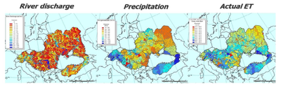
Modelling the Black Sea Catchment hydrology with SWAT from available data (EAWAG partner) 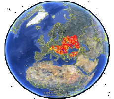
Results exposed as web services on Google Earth 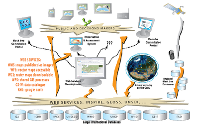
EnviroGRIDS general architecture EnviroGRIDS 27 Partners: UNIGE & UNEP Switzerland; ARXIT Switzerland; AZBOS Ukraine; BSC Turkey; BSREC Bulgaria; CCSS Czech Republic; CERN Switzerland; CRS4 Italy; DDNI Romania; DHMO Ukraine; EAWAG Switzerland; Geographic Georgia; IBSS Ukraine; ICPDR Austria; IGAR Romania; IHE The Netherlands; ITU Turkey; NIHWM Romania; ONU Ukraine; SPBSU Russian Federation; TNU Ukraine; UAB Spain; USRIEP Ukraine; UTCN Romania; VITUKI Hungary; SORESMA Belgium; NIMH Bulgaria. Contact: Anthony Lehmann More information at http://www.envirogrids.net. |