|
|

|
|
Cross-Cutting ActivitiesEuroSITES: European Open Ocean Observatory NetworkIn situ Ocean Observation: A Societal NeedThe global Ocean is a powerful force in regulating our climate. But there is evidence that man is tipping the balance of this delicate system. The oceans act as a vital carbon sink, absorbing carbon dioxide from the atmosphere and fixing it into biological carbon supporting a diverse marine ecosystem including many commercial fisheries and exploitable resources. The open ocean also is a major "power-house," driving ocean circulation and controlling weather systems such as hurricanes and transmitting other natural hazards such as earthquakes and tsunamis. But how will the oceans respond to a changing climate? In situ observing of the marine environment from the surface to the seafloor forms a critical component of the Group on Earth Observations (GEO).
EuroSITES is a network of open ocean observatories across Europe. With funding from the European Commission (Framework 7) and member states, EuroSITES observatories are key contributors to the global ocean observing system. Acting as open ocean reference stations the EuroSITES network provides accurate long-term climate data records of oceanic and surface atmospheric variables in key ocean regions across Europe from the North Atlantic to the Norwegian and Mediterranean Seas (Figure 1). Moorings with surface buoys are used as platforms for multidisciplinary sensors and samplers (Figure 2). These autonomous observatories transmit data on Essential Climate Variables in near real-time from the sea surface to the seafloor to inform science and society, and shape policy. EuroSITES Ocean Science and Technology: Beyond the Current State-of-the-artThe EuroSITES observatory platforms are multidisciplinary allowing many scientific themes to be addressed from biogeochemistry and physics to deep-sea ecology and geo-hazard warning. This supports the motivations of the GEO ST-09-02 by connecting disciplines and promoting science and technology excellence of in situ fixed-point ocean observing. EuroSITES has been closely related with other relevant European and international projects such as ESONET, EMSO, HERMIONE, NEPTUNE, OOI, and OceanSITES. Joint meetings, shared expertise, and best practices among these projects are providing better integration of global fixed-point ocean observation activities and improving interoperability between global observing systems. The EuroSITES observatories also act as key test-bed platforms for emerging technology and innovative sensors and samplers. Science missions range from biogeochemical properties oxygen consumption and ocean acidification to geological, including fluid flow and tsunami warning systems. Ocean Data for Science and SocietyEuroSITES is a key provider of in situ full-depth ocean datasets on Essential Climate Variables (ECVs) (see Figure 4 example). These datasets are open access in near real-time with a common data policy and data format. The datasets are vital for validation of ocean and climate models, for reanalysis using long-term time-series datasets and for inter-calibration with other ocean observing platforms, including ARGO profiling floats and satellites. EuroSITES physical datasets already are available as daily bulletins on the Global Telecommunication System (GTS) and to modelling activities including the European MyOcean. EuroSITES datasets contribute to many of the tasks and societal benefit areas of GEO from climate to ecosystems. These include GEO Task AR-09-03c "Global Ocean Observation System," Task CL-09-03 "Global Carbon Observation and Analysis System, and Ecosystem monitoring. Towards a Sustained Open Ocean Observatory NetworkEuroSITES has produced a pan-European integrated infrastructure of open ocean moored buoys providing key in situ datasets of essential climate variables from the atmosphere (near surface) and ocean interior. This now needs to be sustained and integrated with fixed-point seafloor communities across Europe (ESONET, EMSO) towards a full-depth, real-time, in situ ocean monitoring network producing key products and services for society. This will join the global effort of fixed-point in situ ocean observation platforms contributing to GEO. |
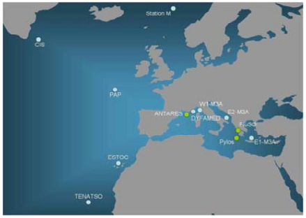
Figure 1. Map of the EuroSITES network 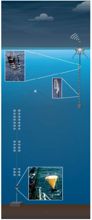
Figure 2. EuroSITES observatory platform 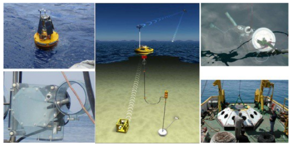
Figure 3. EuroSITES technology and platforms. 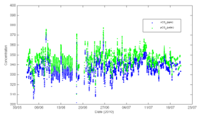
Figure 4. Example of EuroSITES dataset pCO2 from the Northeast Atlantic (PAP) site in 2010 (30 May-25 July). EuroSITES is coordinated by the National Oceanography Centre, Southampton, UK. Partner institutes: 2. UiB; 3. HCMR; 4. OGS; 5. CNR-ISSIA; 6. IFM-GEOMAR; 7. UNIABN; 8. CNRS; 9. IFREMER; 10. Océanopolis-SOPAB; 11. ICCM; 12. INDP; 13. ULPGC. Financial support from the European Commission [Grant Agreement N° 202955] For more information visit http://www.eurosites.info. |